
Places I've Been... By State
Utah is the only state on this page, and is the only State to be split into two parts.
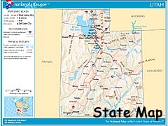
Utah - Page 1
| Page 1 | Introduction | Moab Area | State Routes 12 & 24 |
|---|
| Page 2 | The US-89 corridor | Navajo Tribal Parks | Miscellaneous Places |
|---|
|
|
|
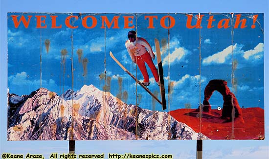
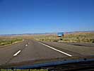
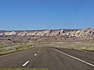
| There are probably better Welcome signs in Utah... |
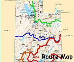
I was first in Utah in 1997, and it quickly became one of my favorite states, (if not the favorite state) to see Mother Nature's handiwork. After my first up-close visit to the Rockies in Colorado and the big gash in Arizona called the Grand Canyon, Utah wasn't a post-awesome scenery letdown, but a took it up a notch with Zion, Bryce, Canyonlands and Arches; then threw in amazing roads like Utah-12, Utah-24 and Utah-128.
It's a geologic wonderland, from the sandstone formations to the South, granite mountains to the Northeast, the Great Basin desert wastelands of the West, and the remnants of a great inland lake to the North. It's central location in the Grand Staircase makes the landscapes change as you travel back through geologic time travelling to the Southwest. Its historical importance ranges from a civilization which disappeared 500 years before Columbus discovered North America, to the Mormons settling the area in the 1800's and the completion of the trans-continental railroad near Promontory, Utah, to the discovery of dinosaur fossils in the badlands. After that, Hollywood would make Utah famous filming every conceivable genre of movie (and television) within its borders.
|
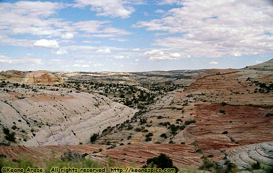
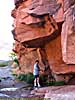
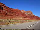
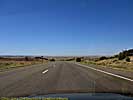
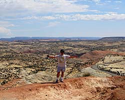
| Petrified sand dunes along Utah-12... |
Speaking of flash floods, watch this incredible YouTube video from a guy who likes chasing flash flood/debris flows in Southern Utah. He's miles from the storm, but pays attention to the weather upstate, and knows approximately when the debris flow will arrive. It will show exactly why you're going to die if you're in one of these, and why you should always check weather conditions if you're going to be hiking or sightseeing in canyons and the wilderness areas.
But if you want to go someplace that has awesome and often stunning landscapes, you can't do better than the Beehive State. I think I have more pictures from Utah than any other state except Florida, not because I've been there many times, but because there's so many different things to see. Perhaps the most obvious example is the Moab area, a place where the Colorado River and the remains of what it did over the past to the landscape is easily accessible.
Utah - Moab and the surrounding area
|
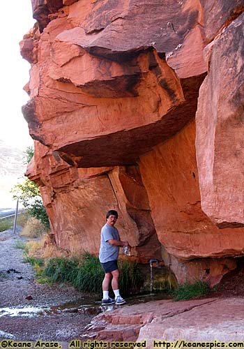
| Getting water at a spring at US-191 & Utah-128. I think this is the spring Maureen O'Hara describes when filming Rio Grande. (The river you see in Rio Grande is actually the Colorado River near Moab.) |
Moab is a small tourist town at the junction of US-191, Utah-128 and the Colorado River. It serves mostly as a base camp for tourists visiting the local sites, though there is a working potash mine at few miles downriver. Being a tourist town doesn't make it a bad place, quite the contrary. Like most places that thrive on tourist dollars, there are small specialty shops, some very good restaurants, even a quick oil change place for those on long road trips. (I've had my oil changed there on two different trips.) Since it is a town of some size, there are also places to re-supply (groceries and the like) should you need to.
You can also book off-road jeep tours of the red rock, and take a jet boat ride down the Colorado River, from Moab to Canyonlands National Park (and back.) I've done this, and it's a spectacular way to see a non-violent section of the Colorado River in canyon country before it enters the National Park System. (See the Colorado River link below.)
I have surprisingly few pictures of Moab itself, but I think I have some video around here someplace. It makes for a very comfortable base camp. The main strip in "downtown" Moab should be explored if you have the time, usually after dinner since many of the restaurants are there. (Though I will say a brew pub anywhere is usually a good choice for food and drink.)
But like any tourist support town, the attraction of Moab, isn't Moab. The main attractions here (imho), are two national parks, one state park and the river that created all of it.
Arches, Canyonlands and Dead Horse Point
Arches and Canyonlands National Parks are the start of the big Colorado River parks after leaving the headwaters in Rocky Mountain National Park in Colorado. One could argue that Colorado National Monument should be shoe-horned in there, but that's another state...
In between the two is Dead Horse Point State Park, a no-brainer stop if visiting the Island in the Sky District of Canyonlands.
All three are spectacular, and rank right up at the top of my list of scenic parks.
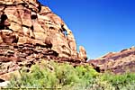
| Arches National Park | |
|---|---|
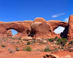 |
Arches National Park is a unique park, a sandstone desert with a unique geology that allows the formation of stone arches. Arches National Park has the greatest density of stone arches in the world. Although it's only a few dozen river miles upriver from Canyonlands, the two parks are completely different in character and content. |
| Near Moab, Utah / 58 Images. Visited Sep 1997, Sep 2005 | |
| Dead Horse Point State Park, Utah | |
|---|---|
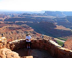 |
Dead Horse Point State Park is right next door to Canyonlands National Park, about a half-mile as the crow flies, or about 11 miles by road. That's just the way things are out here. From the top, you get a magnificent view of the Colorado River Valley and the goosenecks just before entering Canyonlands. Unfortunately, the main view is to the South, so the sun will always be in front of you. |
| Near Moab, Utah / 27 Images. Visited Sep 2005, Sep 2008. | |
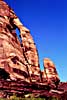
| Canyonlands National Park | |
|---|---|
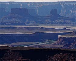 |
Canyonlands National Park is proto-Grand Canyon, and in my opinion even more impressive in many ways. It is the confluence of the Green and Colorado Rivers, a major contributor making the Colorado the powerhouse river of the Southwest. Once the Colorado enters Canyonlands, it doesn't leave Federal land until the river reaches the California. I've only been to the Island In The Sky District, since it was the most accessible. |
| Near Moab, UT / 49 Images. Visited Sep 1997, Sep 2008. | |
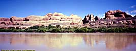
The Colorado River
In 2005, we took a jet boat ride down the Colorado River on a cold, sunny morning with cloudless skies, from Moab to Canyonlands and back. The link below will take you to images from that trip that are on the Colorado River page.
| Colorado River | |
|---|---|
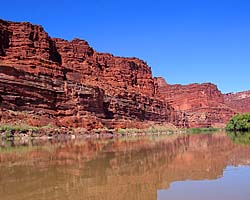 |
The Colorado River starts as a small stream in Rocky Mountain National Park, and gathers hundreds of other streams and rivers along the way to become the lifeline of the Southwest, providing water, electricity and recreation to millions in the five states the river flows through or touches. This link will take you to the Utah portion of the Colorado River page. |
| Colorado, Utah and Arizona / 55 Images. Visited Sep 2005, Sep 2008. | |
Roads: Utah-128 and Utah-279
There are two roads coming off of US-191 at Moab which follow the meanders of the Colorado River. Utah-128 has its own page, but Utah-279 is just a short spur, and its images are below.
Utah-128
Utah-128 is one of those roads that should be driven both ways, from Moab to a few miles past Dewey Bridge. The perspective of the views from the road are very different depending on the direction and time of day.
| Utah State Route 128 | |
|---|---|
|
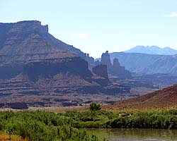
Utah-128 follows the Colorado River's meanders upstream (from Moab) for over 30 miles before turning toward (and joining) I-70. It is one of those roads which seemingly define some of the iconic views of the West, where the Colorado River lazily flows through the Red Rock desert with its sculpted mesas and pinnacles. There are also a couple of images of Cisco, an uranium mining town on US-6 near I-70. |
| Near Moab, Utah, Utah / 28 Images. Visited Sep 1997, Sep 2008. | |
Utah-279
|
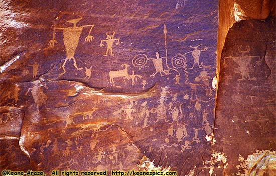
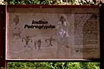
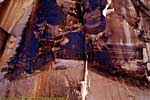
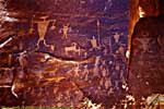
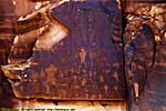
| Thousand year old graffiti along the Colorado River and Utah 279... |
Utah-279 follows the North side of the river, and gives you an up-close view of Wall Street, the local name for the wall of sandstone popular with rock climbers and base-jumpers. It's really pretty much the access road for the Potash mine that's here, and will dead end at the plant. Any other roads you might see leading off of Utah-279 probably requires a four-wheel drive high-clearance vehicle. Check with authorities before trying the roads.
There are a couple of places with visible petroglyphs from the Freemont Culture, the same people as those in Capitol Reef National Park. 1000 year old graffiti scratched into the red rock desert varnish by the side of the river.
Utah State Route 279
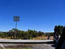
Utah - I-70 (in Utah), State Route 12 and State Route 24
|
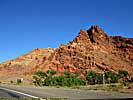
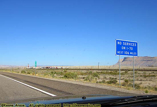
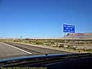
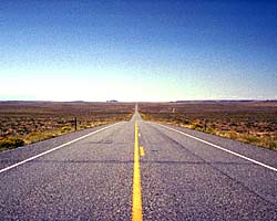
| You definitely don't want to break down 53 miles past this sign... |
I-70 (in Utah) and the San Rafael Swell
One of the more humorous (or ominous) signs I've seen on the Interstate Highway System is to your right. Located on the Westbound side of I-70 just past Green River (at exit 160), it is the start of the longest stretch of Interstate Highway that has no services. Well, there are rest areas, usually with a viewpoint to take in the magnificent panoramas here.
It's not that no one found a need for a service station or hotel 53 miles down the road, but there's virtually no infrastructure to support such a venture. No water, no sewer, no electricity. If you were coming from the West through the Great Basin Desert (mostly via US-6), the difference in scenery as you travel up into the San Rafael Swell past I-15 is startling and welcome, but it's just as hostile an environment as the desert you just left.
What is the San Rafael Swell? Rewind time 40 to 60 million years ago. The Pacific (tectonic) Plate, already being forced under the North American Plate, met a thicker portion of the North American Plate and was forced further down into the Earth. As a consequence, the North American Plate was pushed up.
This upthrust was important in creating "North America" as we know it, draining an enormous inland sea (which split the land mass in half from the arctic to the Gulf of Mexico), and eventually created the Colorado Plateau and the Rocky Mountains.
This area of Utah is close to the edge of the Colorado Plateau, and is known as the San Rafael Swell. Ancient history says there once existed an arid, almost lifeless desert here, where sand was blown in on the winds and was compressed over millions of years into rock. With that are layers of limestone from little dead sea creatures when the area was the bottom of a sea. As the area was pushed into the air over millions of years, those layers of rock cracked, compressed and bent, then were eroded by catastrophic flash floods, wind and rain.
As a result, as you cross the Swell you are travelling through layers of ancient sandstone and limestone, eroded over millions of years to create million dollar views from the seat of your car. However, million dollar views or not, the terrain is so formidable that the only road that goes through the area is I-70. It even serves as the boundary between the "North" and "South" halves of the Swell, since it's the only recognizable landmark
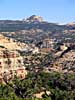
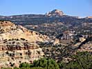
Utah-24
So, before I-70, how did you get through the area? You didn't. You detoured around it. The detour to the North probably involved US-6 and US-89, a detour of about 100 additional miles over the distance I-70 saves you today.
The detour around the South of the San Rafael Swell is Utah-24. Before it was Utah-24, it wasn't a detour, but a road that connected a bunch of Mormon settlements established along the Freemont River after they started expanding outside of Northern Utah. This route was also one of the only ways to get through the "reef", a name referring to the impassable rock wall that stretches for miles. (See the Utah-24 link for more information.)
I've only driven this road from I-70 (near Green River) to Utah-12 in Torrey.
| Utah State Route 24 | |
|---|---|
|
Utah State Route 24 was the southern detour around the San Rafael Swell for 35 years before I-70 opened through the wilderness. Today, it's still the way to get to Goblin Valley State Park, Capitol Reef National Park and the Waterpocket Fold. It is also one of the endpoints of Utah-12, a road everyone should drive at least once... |
| Utah / 35 Images. Visited Sep 1997, Sep 2008. | |
Goblin Valley State Park
Between I-70 and Hanksville a few miles off of Utah-24 is Goblin Valley State Park. The road to the park used to be gravel and the place is literally in the middle of nowhere, so the park was bypassed in my 1997 trip. Then part of the park was used as a location in the movie Galaxy Quest, and they used the location money to pave the road, making the park much more inviting and accessible. But it's still in the middle of nowhere.
| Goblin Valley State Park, Utah | |
|---|---|
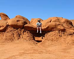 |
Goblin Valley State Park is a very unusual place that has thousands of relatively small stone monuments that the guy who discovered the place called "Goblins". I thought they looked more like mushrooms. Jo thought they look more like... poops. It's only a few miles off of US-24 from I-70, on the way to Capitol Reef and Torrey, the start of Utah-12. It's worth the stop. Just be aware you'll be in the very definition of "Middle of Nowhere". |
| Near Hanksville, Utah / 22 Images. Visited Sep 2008. | |
Capitol Reef National Park
Capitol Reef derives its name from the dome shaped rock formations that (sorta) resemble the dome of the Capitol Building in Washington, and any impassible area, either on sea or land, was referred to as a "reef".
In addition to protecting the Waterpocket Fold, it also protects an old Mormon settlement named Fruita (originally, Junction), where the National Park Service still maintains the fruit and nut orchards along the Freemont River.
While many of the attractions of the park are along Utah-24, the Scenic Drive (which begins at the Visitor's Center) has some of the more impressive sights along the Fold...
| Capital Reef National Park | |
|---|---|
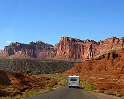 |
Capital Reef National Park protects the Waterpocket Fold, the edge of a geologic upthrust long since eroded away over the last 60 million years. Give or take a few million. The first time I was at the park, the Scenic Drive was washed out due to some flash flooding, so the sights along Utah-24 were the only ones accessible. When I was there in 2008, I had some magnificent weather, a much better planned trip, and spent the entire afternoon in this park. |
| Near Torrey, UT / 95 Images. Visited Sep 1997, Sep 2008. | |
Utah-12, A Journey Through Time Byway
Just to be clear, A Journey Through Time Byway is an official name on the maps, and not a label I decided to put on it. In a way, that name is true, since you'll encounter everything from petrified sand dunes dating back a couple of hundred of millions of years, to the uplift of the Colorado Plateau 70 million years ago, to a vanished civilization from a thousand years ago. But personally, I think the name really belongs to US-89 as it transverses the Grand Staircase from Panguitch, Utah to the Grand Canyon. But that's just me.Utah-12 is one of the most scenic roads I've driven, with Capitol Reef on one end and Bryce Canyon on the other, with all sorts of interesting things in between.
| Utah State Route 12 | |
|---|---|
|
Utah State Route 12 (also named as the "Journey Through Time Byway") is my favorite road in America. The 124 mile road starts at a unnamed junction with US-89 and ends in Torrey, Utah, pretty much connecting Bryce Canyon to Capitol Reef National Park. In-between are a couple of those spectacular Utah State Parks, a National Monument and some jaw-dropping landscapes just off the side of the road. |
| Utah / 67 Images. Visited Sep 1997, Sep 2008. | |
| Anasazi State Park, Utah | |
|---|---|
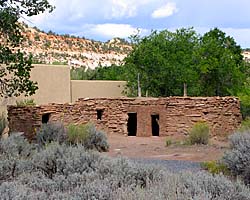 |
Anasazi State Park Museum (UT) is Utah's park dedicated to the Anasazi, who disappeared as a culture some thousand years ago. Too be honest, the ruins are much like those at the other major Anasazi sites, but most of those have been co-opted by the federal government. It is, however, a nice place to get out and stretch your legs, use the bathroom, get something out of the cooler... |
| Boulder, Utah / 15 Images. Visited Sep 2008. | |
| Grand Staircase-Escalante National Monument | |
|---|---|
 |
Grand Staircase-Escalante National Monument is actually larger than the state of Delaware, but has a population close to the number of visitors in the park. Located in South Central Utah, it is an irregularly shaped piece of land that stretches from Capitol Reef National Park to the North, the Arizona State line to the South, Glen Canyon NRA to the East, and Bryce Canyon to the West. The GSENM page starts with an overview of what the Grand Staircase actually is, a geologic wonderland stretching from the Aquaritus Plateau at Bryce Canyon to the bottom of the Grand Canyon. This 8,000 foot drop in elevation in almost discreet steps holds some of the most breathtaking scenery in America. |
| Near Escalante, Utah / 33 Images Visited Sept 1997, Sep 2008. | |
| Kodachrome Basin State Park, Utah | |
|---|---|
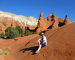 |
Kodachrome Basin is another one of those amazingly scenic Utah State Parks, just a short detour off of Utah-12. The basin was actually named by National Geographic after the new (in 1949) fine grained transparency film from Kodak. When Utah created the state park, the Kodak gave them permission to retain the name. Fast forward almost 70 years, and not only is film an almost dead medium, but there isn't a processing plant left that can actually develop a roll of Kodachrome. |
| Near Cannonville, Utah / 39 Images. Visited Sep 2008. | |
| Bryce Canyon National Park | |
|---|---|
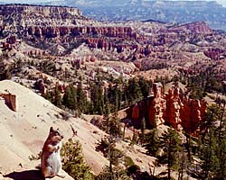 |
Bryce Canyon is just magnificent. The park isn't really a canyon, but a series of amphitheaters of sandstone formations, carved by erosions into pillars that look more like sculptures. It's on my list of must visit parks. Unfortunately, it's also on many other people's list of must visit parks, too. Located a dozen miles from US-89 on Utah-12, it sits on top of the Grand Staircase that descends to the South. |
| At Utah-12 and Utah-63 / 156 Images. Visited Sep 1997, Sep 2008. | |
| Rubys Inn | |
|---|---|
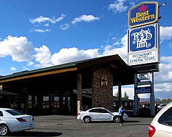 |
Ruby's Inn is named after Ruby Syrett, who promoted the area in 1910, years before Bryce Canyon became a park. As a matter of fact, the Syrett family still owns the land right outside the park, as well as the two hotels, both gas stations, the restaurants, all the gift shops and grocery store. Only the original Best Western existed when I was there, and I stayed in a brand new room with a whirlpool tub right next to the pool atrium. It was rough, but someone had to do it... |
| Near Bryce Canyon National Park, Utah / 25 Images. Visited Sep 2008. | |
| Red Canyon | |
|---|---|
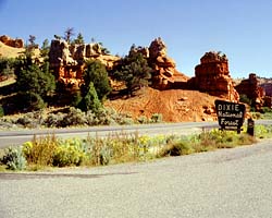 |
Red Canyon is pretty much at the Western end of Utah-12 (mile marker 3), and is a USFS site. I understand there's even a visitors center there now. I've only seen the parts from Utah-12, but there are images from Jo's horseback ride through the canyons. |
| Near Utah-12 and US-89, Utah / 33 Images. Visited Sep 1997, Sep 2008. | |
| Link to: | Utah State Page 2 |
|---|
- 04/30/2016 - Initial deployment
- April 2017 - Upgrade to v3.4.
- September 2022 - Upgrade to v5.0.
| Help! | About This Site | Contact Me |