
Lewis and Clark
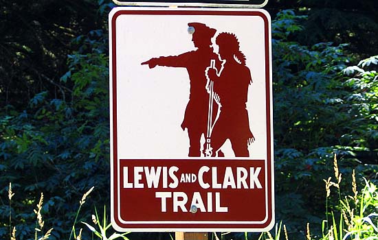
Introduction
I suppose if you really look at it, the trek that The Corps of Discovery took across the continent was the first cross-country Road Trip, in a time where Roads were mostly the rivers that crossed the land. I still have a hard time fathoming (though I do have a much better understanding) of how a group of explorers could cross a wilderness for thousands of miles, across terrain that was utterly alien to them, and almost completely unknown to the culture that attempted the feat. Even more amazing, even with all the risks they took, the Corps only suffered a single causality which couldn't have been prevented at the best hospital of the time. It's a true, real life story of epic proportions.If you go out toward the Northwest, it is almost impossible not to cross their path at some point, though you may not realize it at the time. If you've crossed the Missouri River, you've crossed paths with Lewis and Clark. Same with much of the Yellowstone (where it turns East), the Clearwater, and the Columbia River in Oregon.
While I was always an amateur history buff, my interest in Lewis and Clark didn't really start until 2000, when I happened to come across Meriwether Lewis' gravesite when driving the Natchez Trace Parkway. From there, I read Stephen Ambrose's Undaunted Courage. It gave a fascinating, detailed look at the journey, from Lewis's preparation to his drugged/drunken demise at the gravesite I had visited. It was probably the Ken Burns documentary and the bi-centennial of the event that made me want to go to some of these places, and research on the web showed almost all the Lewis and Clark sites were getting makeovers for the anniversary.
I had already decided that 2005 was going to have a long road trip out West. I hadn't been on one since 2001, when four planes were hijacked with malicious intent on September 11th. We were on our way from Glacier to Yellowstone at the time, and there was a line exiting Yellowstone because the Rangers were writing down license plate numbers. (I do admit that when I went completely digital in 2002, I spent a lot of time in Florida documenting the theme parks.)
There were two rough ideas for 2005. One was to the Northwest and Lewis and Clark, the other the Desert Southwest (Tombstone, Disneyland's 50th anniversary, Death Valley and Yosemite). Well, I have to say, Disneyland was fun!
I don't think I had finished post-processing all the images from my 2005 trip, when I got a call from Jo saying she was going to be in Seattle for a conference at the end of July in 2006. So long as she was out that way, doing a Northwest Vacation would be a very convenient thing to do.
Well, after much arm twisting (cough) we put together some plans. I was on my own out to Seattle, gave myself 5 days, planned a bunch of Lewis and Clark stops before meeting Jo, and a few after as well. On Day 2 of the actual vacation, I was at Fort Mandan, where the Corps wintered in 1804-1805. On Day 8, I was at Fort Clatsop, where the Corps wintered in 1805-1806. One week to do what took them three-quarters of a year, and I took detours to Glacier, Olympic and several other parks, in complete comfort and at speeds that were thought to kill a man back in 1800.
Today, the Roads are now straight and (relatively speaking) smooth, the rivers tamed and supply lines for fuel, food, lodging and almost anything you can imagine exist from coast to coast. The complete opposite of what the Corps encountered, but were more successful in their quest than I probably was on my vacation. They had a lot more time to sightsee, anyway...
The Corps of Discovery
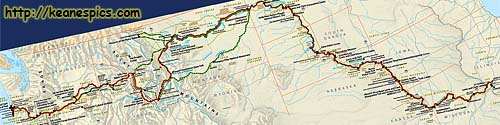
|
| Cropped map of the Corps of Discovery's route. Click on the map for a larger view. |
Later explorers would find there was no shortcut, that this newly discovered land mass had no direct connection between the Atlantic and Pacific Oceans without sailing to the South end of the Earth. Yet the people of the day were sure there was still and easy way to cross the new continent, using the waterways of North America. They were looking for the Northwest Passage, an easy route between Europe and Asia.
Thomas Jefferson wanted to know if such a passage existed, and if there was one, he was sure up the Missouri River from the East, and the Columbia River to the West. If they could find it, the United States would become a major player on the world stage. He also had books with theories on what was to be found in the interior, and Jefferson always was the curious type.
As President, Jefferson got congress to appropriate some funds to send an expedition to the West, to explore the Missouri River across the big blank area on the map between (what was to become) North Dakota and Oregon/Washington. It was in the United States best interest to find what else lay on the same continent as their new country.
Pennsylvania
Jefferson selected his trusted aide, a fellow Virginian and almost neighbor, Captain Meriwether Lewis to head the expedition. In preparation for the journey, Lewis was sent to study medicine, botany and zoology with the best minds of the day, who all gathered in the former capitol, now the center of learning in America, Philadelphia.It was during his tenure in Philadelphia that France offered the Louisiana Territory to the United States (mostly to irritate England,) and Jefferson bought it. The U.S. now owned a large swath of land from the Mississippi to the Rocky Mountains, doubling the size of the United States. Lewis' mission become much more important, not only to find the Northwest Passage, but to find out what Jefferson had just bought. He was tasked to document and map his travels, and establish preliminary diplomatic links with the native people along the way. And he was pretty much given a blank check to do it.
If you ever go to Independence Historical Park, you'll find the focus is mostly on Ben Franklin (the most important local resident) and the founding fathers. Lewis came here as a student and to research how to plan, equip and execute a trip across the unknown without any supply line or means of support.
I consider the start of my crossing paths with Meriwether Lewis in Philadelphia, even though I have no images or evidence that could directly connect to Lewis. He may have very well visited some of these places, such as the Christ Church graveyard to pay respects to Mr. Franklin, and the Pennsylvania State House (now Independence Hall). Perhaps even the post office Mr. Franklin had started to send a letter home...
| Independence National Historic Park | |
|---|---|
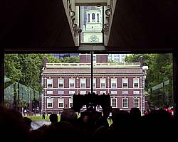
|
Independence covers a couple of square miles of Philadelphia's historical district, protecting things like the Liberty Bell and one of the original copies of the Declaration of Independence. Farther afield are historical places like the Betty Ross house and the Franklin Institute. While you're there, a side trip to the Philadelphia Mint is a must. It's where half of the change in your pocket was made. |
| Philadelphia, Pennsylvania / 35 Images. Visited Jun 2001, Oct 2006. | |
After preparing as much as possible in Philadelphia, Lewis made his way down the Ohio River where the keelboat was constructed, collected the best men from military outfits along the way, including picking up his old army buddy, Lt. William Clark near what is now Louisville, Kentucky.
United, they headed down the Ohio to the Mississippi, then upriver to a place just past St. Louis right across from the mouth of the Missouri in Illinois, where they wintered over in 1803-1804.
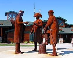
The cast (so to speak) of The Corps of Discovery wasn't complete until
they arrived at the Mandan Villages in late 1804, where they built a fort
and wintered over. Here they picked up a mediocre guide by the name
of Charbonneau, and was pretty much tolerated only because he had a wife
named Sacagawea (and one should note a pregnant Sacagawea), who
could speak a couple of different native dialects and could translate
for the party.
So we can sum up the story so far. They have travelled some 1000 miles up the Missouri River. About halfway, they lost Sergeant Charles Floyd in Iowa by natural causes. (Most likely a burst appendix, fatal in the day.) They will winter over at a spot next to the Missouri River approximately 40 miles North of what is now Bismarck, North Dakota. They will build a fort named Fort Mandan after the local tribe that welcomed them here, and endure temperatures of -40 degrees Fahrenheit during the coldest nights. No indoor plumbing, remember, and there were 10 to 15 grown men in the enlisted quarters, so no privacy.
In the Spring of 1805, after the ice has broken up on the river, the keel boat which has been the main support vessel for the Corps, will be sent back to St. Louis with the samples of flora and fauna collected so far. The Corps would travel mostly by canoe now, as the river became shallower and less navigable for a large bottomed boat.
Interpretive/Visitor's Centers
For the 200th anniversary of the Corps of Discovery's journey, Lewis and Clark interpretive centers have sprung up all along the route, either new buildings or spiffed up existing ones, from Saint Louis to the Pacific Ocean.While I might joke that all the interpretive centers have the same stuff, I'll still point out that each one is worth a visit, if you have the time. Each has a specific focus on what the Corps did in the local area.
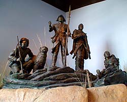
However, there are common things between all of them, like the cast of characters in this sometimes unbelievable production.
North Dakota
The first Lewis and Clark site I visited in 2006 was Fort Mandan. There was a new Interpretive Center that's actually separate from the Fort and its visitor's center.The Fort is an accurate reproduction, though in an approximate location. The years have completely erased the original fort, and the written journals can't give a fixed location where it was built.
| Lewis and Clark Interpretive Center (ND, Fort Mandan) | |
|---|---|
|
Fort Mandan was where the Corps spent their first winter. Or at least someplace around where the replica fort is today, it's true location is unknown. The interpretive center is new and a couple miles from the Fort, which has it's own visitor's center. I purposely avoided a bus tour, and got me a private tour of the Fort. It was actually a pretty cool tour. |
| Near Washburn, North Dakota / 20 Images. Visited Jul 2006. | |
Montana
1804 was a pretty tough year for Lewis and Clark, and it all started around here. They knew of the waterfall here, told to them by the friendly native tribes. What they didn't know, was the series of rapids and waterfalls went on for scores of miles, and they would have to portage around all of them.
Even worse (though they didn't know it at the time), by following the Missouri River to its source, they made a giant "U" shaped route. They would later find that by taking a land route across the top of the "U", they could have saved over a month of travel time and avoided the nearly deadly trek across the snowy, Bitterroot Mountains.
The river is dammed and tamed now, and I was there in the late summer, so the snowmelt was long gone, and Great Falls, wasn't so great.
| Lewis and Clark Interpretive Center (Great Falls, Montana) | |
|---|---|
|
The area around Great Falls on the Missouri River was the first serious obstacle the Corps of Discovery had underestimated about the West. Mile after mile of un-navigatable rapids and waterfalls, where they had to portage hundreds of pounds of canoes and supplies by foot. The Missouri River's been long tamed now, even more so during the fall when I was there, months after the mountain snowpacks had melted. But even 200 years later, it was easy to see how this area of the Missouri would be hell by canoe... |
| Near Great Falls, Montana / 15 Images. Visited Jul 2006. | |
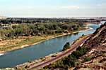
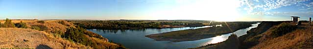
I-94 follows the Yellowstone River from Livingston to Glendive in Montana, the route William Clark and his part of the company explored on the return trip from the Pacific.
There is a rest area in Eastern Montana that has an nice overlook of the Yellowstone, possibly the same view Clark and company had 200 years before. The railroad tracks weren't there, though. Heh.
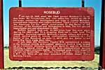
Yellowstone River, from an I-94 Rest Area (between Rosebud and Hathaway, MT)
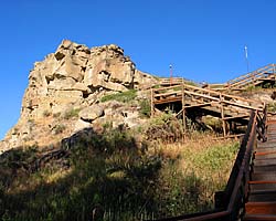
Pompy's Tower (named after the child that was born during the journey) has the only physical evidence of the Corps of Discovery's journey across America, in the form of some graffiti William Clark scraped into the side of the rock on July 25, 1805. It's well documented in his journal.
By sheer coincidence, I was at Pompeys Pillar on July 25, 2005, 200 years to the day after Clark defaced the rock. But I was there and gone before the festivities took place.
It's not exactly clear how the place got to be called Pompeys Pillar, but I did climb to the top of it, and I have the t-shirt to prove it.
| Pompeys Pillar National Monument | |
|---|---|
|
Pompeys Pillar National Monument holds the only physical evidence of the Lewis and Clark's trek across America. On July 25 in 1806, William Clark climbed this rock and scratched his name onto the side of the limestone formation. I was there 200 years to the day after the deed. |
| Near Pompeys Pillar, Montana / 20 Images. Visited Jul 2006. | |
Idaho
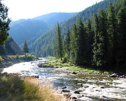
| US-12, Northwest Passage Scenic Byway | |
|---|---|
|
I drove the Northwest Passage Scenic Byway (also known as the Lewis and Clark Trail and the Nez Perce Trail), because I was doing a bunch of Lewis and Clark sites in July 2006. The road doesn't exactly follow the Lolo Trail through the Bitterroots, but it's a stunningly beautiful road, following the Lochsa River (and eventually the Clearwater) through the Bitterroot Mountains. There are also images of the Nez Perce National Historical Park (East Kamiah). |
| Idaho / 65 Images. Visited Jul 2006. | |
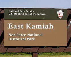
| Nez Perce National Historic Park | |
|---|---|
|
I was only at the East Kamiah unit of the Nez Perce NHP, but I guess if you're going to be at any of the part of the park, it might as well be the place where the tribe was born from the blood of the monster. It is along the Northwest Passage Scenic Byway (US-12). (This link will take you to the US-12 page.) |
| East Kamiah, Idaho / 7 Images. Visited Jul 2006. | |
Pacific Northwest
| Columbia River | |
|---|---|
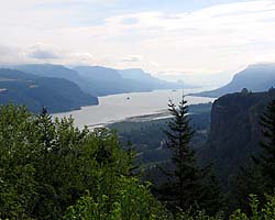
|
In 2006, I was doing a Lewis and Clark thing, and you can't do Lewis and Clark without seeing the Columbia River Gorge. It's an impressive river, the only river route through the Cascades. I encountered the river twice, once in Washington where I-90 crosses the Columbia, and the other was following the Columbia River Gorge from Portland to I-82 where I-84 turns to the Southwest as the river turns to the North. |
| Oregon, Washington / 50 Images. Visited Jul 2006 (Oregon), Jul 2006 (Washington). | |
| Cape Disappointment State Park, Washington | |
|---|---|
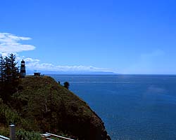
|
If you like lighthouses, Cape Disappointment State Park has two of 'em. The original lighthouse on Cape Disappointment, and it's replacement, the North Head Lighthouse. It's also the overlook that the Corp of Discovery camped at, hoping to flag down a passing ship. Lewis and Clark didn't name it, but they were disappointed. An interpretive center overlooks the lighthouse. I also have an image of the sign where Station Camp was located on the Pacific Coast. |
| Near Ilwaco, Washington / 28 Images. Visited Jul 2006. | |
| Fort Clatsop, Lewis and Clark State and National Historic Park | |
|---|---|
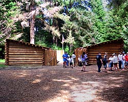
|
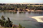
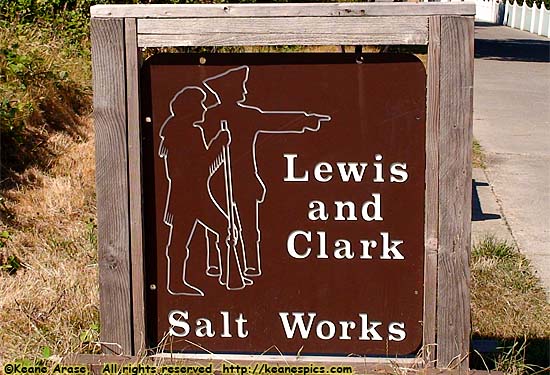
My 2005 Pacific Northwest Vacation had me to a bunch of Lewis and Clark sites, including Fort Clatsop, where the Corps of Discover stayed their second winter. Of course, the fort burned down a few months before I was there, so the images I have are of a bare fort with no furnishings. There are also images of the Salt Works (near Seaside), where the Corps boiled down sea water for salt. The site is literally in someone's back yard... |
| Near Warrenton, Oregon / 22 Images. Visited Jul 2006. | |
Tennessee
| Meriwether Lewis Burial Site (Natchez Trace Parkway) | |
|---|---|
|
I was first at the Meriwether Lewis Burial Site on the Natchez Trace Parkway in 2000, but it wasn't until closer to the bi-centennial of his trip to the West that I did a lot more research into the Corps of Discovery. I went back in 2011, when I found myself about a hundred miles away from the site. This link will take you to the Natchez Trace Parkway Page. |
| Near Hohenwald, Tennessee / 22 Images. Visited Mar 2000, Nov 2011. | |
|
| Salt Works... |
- 04/30/2016 - Initial deployment
- April 2017 - Upgrade to v3.4.
- September 2022 - Upgrade to v5.0.
| Help! | About This Site | Contact Me |